The Streams Beneath Your Feet: America's Buried Geography and the Memory That Vanished With It
What the Map Does Not Show
If you stand at the corner of State and Madison streets in downtown Chicago—the intersection the city uses as its official address grid origin—you are standing above a buried world. Beneath the concrete and the utility conduits and the transit tunnels lies the memory of a landscape that determined why Chicago exists where it does: a low, marshy portage between the Chicago River system and the Des Plaines River that connected the Great Lakes to the Mississippi watershed. The specific streams that made this portage possible were, over the course of roughly a century, straightened, deepened, rerouted, and in some cases simply enclosed in culverts and forgotten. The city that grew above them has no visible relationship to the hydrology that created it.
Chicago is not unusual in this respect. It is simply among the most dramatic examples of a phenomenon that recurred across American urban development: the systematic erasure of the natural waterways that had originally structured settlement, followed by the equally systematic erasure of memory of those waterways from the consciousness of the people living above them.
The Chicago River and the Engineering of Forgetting
The manipulation of Chicago's water geography began almost immediately after serious settlement commenced and accelerated with each decade of the city's growth. The Chicago River, which originally drained into Lake Michigan, was reversed in 1900 through one of the largest civil engineering projects of its era—a canal and channel system that sent the river's flow away from the lake and toward the Mississippi watershed, solving the city's sewage problem by making it someone else's downstream concern.
This reversal is relatively well known, at least among Chicagoans with an interest in local history. Less well known are the dozens of smaller waterways that were altered, buried, or eliminated in the same period. Bubbly Creek—the south branch of the Chicago River that received the waste output of the Union Stock Yards—was so thoroughly contaminated by the meatpacking industry that it ceased to function as a water body in any biological sense for most of the twentieth century. The name persists; the creek, in any meaningful sense, does not.
The North Shore Channel, the South Branch improvements, the straightening of the Calumet River system—each of these projects removed another element of the original landscape, replacing organic waterways with engineered channels optimized for navigation, drainage, or industrial use. The cumulative effect was a city whose relationship to its own hydrological foundation had been almost completely severed within a few generations of its founding.
What makes this psychologically significant is the speed of the forgetting. Chicago residents born in 1920 grew up in a city whose older residents could still remember the pre-reversal river. Chicago residents born in 1970 grew up in a city where the altered geography was simply the geography—not a modification of something prior, but the natural state of things. The landscape teaches its own history to the people who live in it, and when the landscape is changed, the lesson changes with it.
Los Angeles and the Concrete River
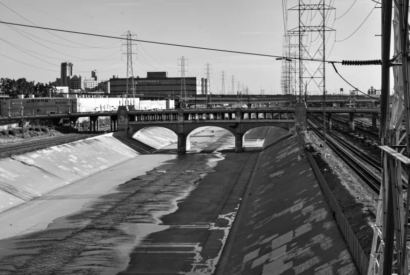
The Los Angeles River presents a different version of the same story, complicated by the particular mythologies that surround Southern California's relationship to water. The river that existed before European settlement and well into the American period was a seasonal waterway of considerable variability—dry gravel wash for much of the year, dangerous flood channel after winter rains, and in its natural state a significant ecological resource that supported the Tongva communities who had lived along it for centuries.
The channelization of the Los Angeles River, completed by the Army Corps of Engineers in the 1930s and 1940s, converted approximately 51 miles of this waterway into a concrete-lined flood control channel. The engineering rationale was sound by the standards of the time: catastrophic floods in 1934 and 1938 had killed hundreds of people and caused enormous property damage, and the channelization effectively ended the flood risk. What it also ended was any meaningful ecological or aesthetic relationship between the city and its primary waterway.
The concrete channel that most Angelenos recognize—familiar from car chases in action films and the occasional news segment about homeless encampments—bears no visual or functional resemblance to the river that determined where Los Angeles was founded. The original river's course shaped the location of the Spanish missions, the alignment of the pueblo that became the city's downtown, and the agricultural patterns of the early American period. The channel that replaced it is a piece of infrastructure, not a geography.
Recent efforts to restore portions of the Los Angeles River to something approaching a natural state have generated fierce debate, and that debate is itself instructive. Residents who have lived near the concrete channel for decades experience the restoration proposals as changes to the landscape they know, not as restorations of a landscape that preceded their knowledge. The original river is not part of their mental map of the city. The engineering is. The erasure has become the baseline.
The Straightened Rivers of the Midwest
Beyond the major urban cases, the agricultural Midwest contains perhaps the most extensive landscape of erased hydrology in North America. The drainage of the prairie wetlands and the straightening of the region's rivers and streams was one of the largest deliberate modifications of natural geography in human history, accomplished between roughly 1850 and 1950 through a combination of federal programs, state drainage districts, and individual farm improvement projects.
The Kaskaskia River in Illinois, the Embarras, the Little Wabash—these waterways were straightened, deepened, and stripped of their natural meander patterns to improve agricultural drainage on the surrounding land. The ecological consequences were severe and are now extensively documented: loss of wetland habitat, increased flooding downstream as water moved faster through the system, degraded water quality. The historical consequences are less discussed but equally significant.
The original courses of these rivers were not merely aesthetic features. They were the organizing logic of the landscape—the reason settlements were placed where they were, the reason roads ran at particular angles, the reason certain land was farmed and other land was not. When the rivers were straightened, the logic that had organized the human geography of the region was severed from the landscape that had generated it. Towns that had been founded at natural river crossings found themselves sitting beside artificial channels that bore no relationship to the natural hydrology. The history of why those towns existed where they did became, for most residents, simply unknown.
Why Erasure Feels Permanent
The psychological question at the center of all these cases is not why societies erase their geography—the economic and safety rationales for each of these projects were real and in many cases compelling. The question is why the erasure feels so complete to the generations that come after.
The answer appears to lie in the way human beings establish their sense of place. We do not inherit a landscape's history through documents; we inherit it through the landscape itself. The shape of a river teaches its own story to the people who grow up beside it. The presence of a stream beneath a city street communicates nothing to the pedestrians above it. When the physical record is removed, the psychological record follows within a generation or two, because the object that would have prompted the memory no longer exists to prompt it.
This is not a failure of education or civic attention. It is a structural feature of how human memory of place actually works. History is recorded in landscape as surely as it is recorded in archives, and when the landscape is rewritten, the record it contained is overwritten with it. The buried rivers of American cities are not merely engineering artifacts. They are a lesson in how thoroughly a society can forget what it has done to the ground beneath its feet—and how little it takes to make that forgetting feel like the natural order of things.