Engineered Isolation: The Street That Ends Here Was Designed to End There
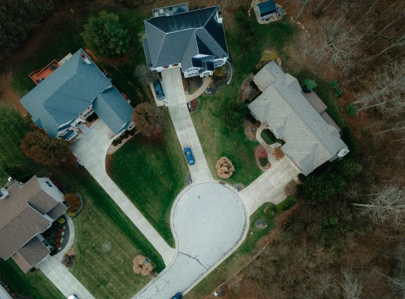
There is a particular kind of American street that announces itself through absence. It has no through traffic because it connects to nothing. It has no strangers passing through because strangers have no reason to arrive. It is, in the vocabulary of urban planning, a cul-de-sac—and in the vocabulary of social history, it is a decision about who belongs near whom, rendered in asphalt and concrete so permanent that most residents never think to question it.
Human beings have always organized space to reflect social hierarchy. The walled quarter, the servants' entrance, the railroad track as neighborhood boundary—these are not inventions of the modern era. They are expressions of a psychological constant: the desire to translate status into geography, to make the social order legible through the built environment. What changed in twentieth-century America was the sophistication of the mechanism. The cul-de-sac offered something the explicit exclusionary covenant could not: plausible neutrality.
The Utopian Origins of an Exclusionary Tool
The disconnected street grid did not begin as an instrument of segregation. Its intellectual ancestry lies in the English Arts and Crafts movement and the garden city theories of Ebenezer Howard, who imagined communities where curving, intimate lanes would replace the relentless industrial grid. Raymond Unwin and Barry Parker translated these ideas into physical form at Letchworth and Hampstead Garden Suburb in the early 1900s, designing street networks that prioritized pedestrian calm over vehicular efficiency. The dead end, in this tradition, was a gesture toward domesticity—a way of saying that this place belonged to its residents rather than to the city at large.
American planners imported the aesthetic without always importing the egalitarian intent. Clarence Perry's 1929 "neighborhood unit" concept, enormously influential in American planning circles, codified the idea that residential areas should be bounded and internally focused, with arterial roads forming barriers at the periphery and local streets serving only local traffic. The logic was simultaneously architectural and social: if you controlled who could conveniently move through a neighborhood, you exerted significant influence over who would live there.
By the postwar suburban boom, the disconnected street grid had become standard practice—not as a utopian gesture but as a development formula. Builders and planners discovered that cul-de-sacs allowed them to maximize lot yield on irregular parcels, reduce road maintenance costs, and—not incidentally—create neighborhoods that were physically difficult for outsiders to navigate or traverse. The result was a landscape that looked like a preference for quiet living but functioned as a system of selective access.
The Traffic Engineer's Invisible Hand
When researchers study the geographic distribution of street connectivity in American metropolitan areas, a pattern emerges that is difficult to explain through traffic engineering alone. Neighborhoods with lower median incomes and higher proportions of residents of color are systematically better connected to the surrounding street grid than wealthier, whiter neighborhoods nearby. This is not accidental. It is the accumulated record of decisions made across decades by planners, developers, and municipal officials who understood that connectivity is a form of exposure and that exposure, in the American context, carried social meaning.
The mechanism was rarely explicit. No zoning ordinance announced that dead ends would be used to separate the comfortable from the less comfortable. Instead, the separation was achieved through the ordinary operation of the real estate market, the preferences of developers building for buyers who had strong opinions about what kind of neighborhood they wanted, and the willingness of municipal governments to approve subdivision plats that formalized those preferences in the street network itself.
This is where the history of urban planning intersects with the psychology of human nature. The desire to live among people who resemble oneself—in income, in background, in social aspiration—is not a peculiarity of any particular era or culture. It appears consistently across the historical record, from the occupational quarters of medieval cities to the ethnic enclaves of nineteenth-century American industrial towns. What varies across time is the mechanism through which this desire is expressed and the degree to which that mechanism carries legal sanction or social approval.
What Disconnection Costs
The social consequences of the disconnected street grid extend well beyond the original intentions of its designers. Neighborhoods built around cul-de-sacs generate more vehicle miles traveled per resident, because every trip—regardless of destination—must exit through the same limited number of arterial connections. They produce higher rates of automobile dependency, which in turn produces higher transportation costs as a proportion of household income, which disproportionately burdens lower-income residents who may have been steered into more connected but less desirable neighborhoods. The geography of exclusion thus generates secondary costs that fall on those who were excluded.
There is also the matter of social capital. Researchers studying neighborhood interaction have found that street connectivity correlates with rates of casual social encounter—the sidewalk conversation, the awareness of a neighbor's routine, the informal surveillance that makes streets feel safe. The cul-de-sac, whatever its intentions, tends to concentrate social life within a small group of households while reducing contact with the broader community. This is experienced by residents as intimacy and privacy; it is experienced by those outside the dead end as a signal that they are not expected to pass through.
Both experiences are accurate. Neither is neutral.
The Record in the Pavement
Urban historians face an unusual challenge when they attempt to document the social intentions embedded in street design. Unlike the racially restrictive covenant, which left a written record in the deed books of county courthouses, the disconnected street grid leaves its evidence in the landscape itself—in the precise location of T-intersections and cul-de-sac bulbs, in the way a subdivision boundary aligns with a municipal line, in the relationship between a neighborhood's internal connectivity and the quality of the roads that bound it.
Reading this record requires the same interpretive patience that any historical inquiry demands. The street that ends here did not end here by accident. Someone drew that line on a plat map, and someone approved it, and the community that formed around it absorbed the assumption of its geometry—that this place was for these people, that the absence of a through connection was not a limitation but a feature.
Five thousand years of human settlement patterns suggest that the impulse to organize space according to social preference is not going away. What changes is whether communities choose to examine that impulse or allow it to continue operating anonymously, encoded in the infrastructure that future generations will inherit as simply the way things are. The dead end is never simply a dead end. It is a decision, and decisions have authors, and authors had reasons—reasons that, once examined, reveal more about the psychology of community formation than any controlled experiment ever could.